Friday, March 30

FRIDAY
This morning the sky was covered in stratus clouds. There is no precipitation, and we are still receiving winds from the east because there is now a string of low pressure systems that have developed to our south. Because of this I anticipate that for the next day or two we will have off and on rain and cloudy conditions-this is bad news for me because I have a lacrosse tournament this weekend!! The water vapor map shows that there is a lot of moisture in the atmosphere right now, which further backs up my statement that we will be continuing to receive precipitation for a while.


THURSDAY
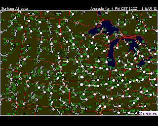
Today on my walk to class there was a mackerel sky, which signals there is a change in wind pattern! The winds were now coming from the east, which means that we can probably expect rain in the next 24 hours! If the winds from the east aren’t enough of a hint that rain is on the way, the barometer was dropping all day, which means that precipitation is in the near future. Although the day was beautiful, around 11:30pm it began to rain. I’ve never had the opportunity to look at weather maps while its been raining, so I took this moment to gather the following charts:


You can see that the low pressure system to our southwest is bringing the storm with it-and it is the reason why we are getting winds from the east. Since low pressure systems rotate counter clockwise, the eastern winds above it were affecting us. As soon as it passes we can be expecting winds from the west, as well as clearing conditions for a while-at least along the lines of precipitation.

Wednesday, March 28

Weather Blog #16

Although I have not posted in the last couple weeks it does not mean I haven't been paying attention to the weather! I spent most of the last two weeks without internet because I participated in a class in New York through the UWEC art & design department, so I do not have graphs and charts to back up my findings, but I do have a few photos of clouds that I took myself!

I'm starting to find it a little easier to predict how the day is going to go based on the cloud patterns in the morning, and when I'm correct it's really exciting!!

My first experience with this was two weeks ago when the warm front came through for the first time ( I believe it was tuesday, march 13th). I spent my day in the graphic design lab, but each time I looked out the window I saw a different type of cloud. By the time it was sunset it dawned on me that it was a warm front cloud pattern! The day began with cirrus clouds, moved into altostratus and then stratus clouds. I said to the friends I was with that it was going to rain before morning and they didn't believe me-but low and behold when we left the lab at 2:30am to go get a snack it was pouring rain!

Another experience that I had was last week in New York City. In the morning there were cumulus humulus clouds scattered across the sky and I told everyone to watch them because if they began to grow taller it would mean rain. Throughout the day they got bigger and covered more of the sky, and there was a little bit of vertical development so I said that we could probably expect some rain in the next day. The next morning when we woke up to go to Good Morning America it was raining! Here is a picture of the cumulus humulus clouds that I had seen the day before:

Sunday, March 11

Weather Blog #15

Today was extremely warm! We had clear skies in the morning, but as the day progressed we saw more and more clouds until finally around sunset the cloud was about 80% covered with stratus clouds. I believe that I was watching a warm front approaching-which means that we should see precipitation soon. When a warm front approaches, it gets warmer (obviously) which happened today, also it begins with cirrus clouds, then cirrostratus then altocirrus then stratus (which is what we saw around 7pm) then nimbostratus-which should appear by tomorrow. Also, we were recieving winds from the south-and usually when wind direction is anywhere from northeast to south you can expect precipitation within the next day.


THURSDAY
I was correct in predicting that the weather will continue to get cooler, and also in expecting our barometric pressure to rise! We have broken clouds today-and many different types! It looks like there are some altocumulus clouds, and some cirrus clouds. Although this wind map shows winds of only about 10mph coming form the northwest, they picked up as the day went on and by 6pm they had to be at least 25-30mph, and very cold!


The east coast is getting a storm today. I believe it is from the same system that caused it to rain here the other day. As the storm moved towards the east, it started receiving wind from the continental tropical air mass, and since warm air  can hold more moisture that cool air, the storm appears to have grown and it looks like the east coast is getting more precipitation than we did.


WEDNESDAY
Today is cold and rainy. We were correct in predicting that it would rain today! We have 100% cloud cover-nimbostratus clouds. We also have a cold front moving through and winds from the south/southwest at about 10 mph. As soon as the cold front passes through we will see a shift in wind direction because there is a high pressure system located to the northwest of us. This means that our winds will shift to northwest winds and it will continue to cool down because we will be receiving air from the continental polar air mass. Also, when our winds change we should expect clearing conditions because there are no clouds to our northwest. We can also expect our barometric pressure to start rising because we will be receiving air molecules that are trying to even out the high/low pressure discrepancies, therefore our pressure will increase.


TUESDAY
Today we have some interesting weather going on. We have cirrus clouds and winds from the east which means that precipitation is going to come in the next day. I learned that generally when we have winds anywhere from the NE to SE we can expect to see precipitation. Our atmosphere is conditionally unstable right now because the yellow line stays in between the two white lines for a long period of time before crossing over to the left of them. The day was really nice-we had temperatures in at least the 40s, very little wind, and clear skies. It’s too bad I’m busy all day because it would be great to spend some time outside!


MONDAY 
Today was overcast. We had winds at about 10mph from the south.  We are getting winds from the south because there is a high pressure system to our south and a low pressure system to our north west, therefore the winds are rushing from high to low pressure which is why we have winds from the south. Aside from this, there really isn’t much going on in the country right now-a couple of low pressure systems are on the edges of the country-one in the northwest and one out on the east coast. 


Wednesday, March 7

Weather Blog #14

Today we had overcast skies-in the morning it appeared to be stratuscumulus but as of late afternoon they seem to be just stratus clouds. we are getting wind from the southwest which is driving the cold front from the colorado region towards us. also the temperature is in the mid-high 30s-all the snow from last weeks storm is starting to melt!

The barometric pressure is rising so we should see a stop in precipitation and clearing throughout the night.


Sunday, March 4

Weather Blog #13

"All About Clouds"


Today there were some very interesting cloud patterns to look at! This morning I awoke to what appeared to be Altocumulus Duplicatus clouds. In Field Guide to Weather it says that these types of clouds can often appear as multi-layered & disorganized, which is exactly what I saw. I was unsure of what type of cloud it was at first because it looked in some areas to be cumulus, and in some areas to be almost stratus or cirrus. These clouds mean that there is a lot of moisture being carried over a long distance-which can be related to the water vapor map below. You can see that there as a lot of water vapor to our northwest, and since we are located right under the jet stream and receiving winds from the northwest, it makes sense that this water vapor is being carried over us by these Altocumulus Duplicatus clouds that are traveling via the jet stream.


However, this afternoon the clouds have changed. The only type of cloud that I believe this cloud looks like is the stratocumulus undulatus cloud. These are low clouds also associated with moisture. They often bring light precipitation-such as flurries or light rain. Because of this, I predict that there is a chance of precipitation later.


Thursday, March 1

Weather Blog #12

SATURDAY
Today we have 100% cloud cover-cirrostratus clouds. Our atmosphere is extremely stable so I wouldn’t count on having any storms today. We are getting winds from the west/northwest at about 10 mph and there is a low-pressure system sitting on top of us. You can see the winds correlate with the low-pressure system-as they are shifting in a counter clockwise direction around our area.


The storm from yesterday is continuing to move eastward and is hitting the east coast today. I wonder if it is still carrying the same intensity that it was yesterday.

FRIDAY
While today was pretty boring weather-wise in the Midwest, there was some crazy weather going on elsewhere in the country so I’m going to talk about that!

Today while I was at work I heard on the radio that there were horrible tornadoes popping up from the south all the way up through the Midwest. The main states it affected was Tennessee, Kentucky, Ohio, Indiana, and southern Illinois. I was curious to see some maps and charts of this type of weather, so today I looked up yesterday’s information and this is what I found:

You can see that there is a low-pressure system moving through the south. It is set up just like it was when we got our bad storm a few days ago-it has a cold front off the southwest and a warm front to the east of it.


If you look at the stability chart for Tennessee you can see that yesterday Friday morning it was completely unstable. This means that it will be a lot more likely to see severe weather because the atmosphere is so unstable. As the storm passed, you can see that it starts to shift and the atmosphere is on the verge of becoming condionally unstable, which is better, and soon I’m sure it will become stable again.


The stability chart for Illinois shows that it has a pretty stable atmosphere; however, I heard that an entire town was wiped out by tornadoes. I am curious to see what a stability chart would look like in that area-I’m guessing it was not the same area where this data was collected.


THURSDAY
We had 100% cloud cover today. There were light winds coming from the northwest. The atmosphere is very stable-you can see this because the yellow line on the stability chart remains to the left of the two white lines for the majority of the chart.


Overall there are a lot of low-pressure systems & much cloud cover of the united states. This leads me to believe that there will be some more precipitation and possibly bad weather in the next couple of days.


WEDNESDAY

In the morning there was 100% cloud cover and throughout the day we had light flurries and rain. Winds were coming from the east as the Low pressure system passed us, and eventually shifted by the end of the day and they were coming from the north/northwest. Here is a map of the storm on wednesday morning-you can see there is an acluded front attached to the Low pressure system now which means that it is dying out.


By late afternoon the clouds were clearing and the snow storm, with less intensity than initially expected, had passed. Here are two pictures I took of the clouds this afternoon. The first picture shows some Altocumulus Undulatus and the second picture shows what looks to be Stratocumulus Undulatus.