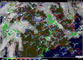
Here is a surface map of wednesday, to show that we were on the backside of the low pressure system. It makes sense that it was slightly to the west of us because temperatures didn't drastically drop as they would have if we had been more directly behind the cold front.
It happened again yesterday! I noticed the same type of clouds and predicted that today would be cool-low and behold I awoke to a sky blanketed in stratus clouds and temperatures that made it chilly even in a sweatshirt and pants! I really like that I have been able to pick up on these patterns because this will be extremely useful to know what type of weather to expect in days to come incase I am planning on being outside!
It's funny because on both of these occasions I was with friends, and shared this information with them. They brushed it off like I didn't know what I was talking about, and then the next day, when my predictions had been correct, they were impressed that I was right and wished they knew these types of things too :)
I fell like when we originally learned about these types of clouds, it was supposed to signal changing winds in a good way, that the next day would be nicer. But I have come to notice that it depends on what type of pressure system is near you and also what the weather previously was. If its really nice out, and the winds start changing, chances are its going to become cooler. If its already pretty crappy out and the winds start changing, the new wind direction will push out the crappy weather and it will get nicer!
Here is a surface map of today:


No comments:
Post a Comment