Tuesday, February 28

Weather Blog #12

"Tracking the Storm Pt. 2"

Today I learned that whenever the midwest gets a huge storm during the winter, it always stems from a Colorado low.

As you can see, the Barometric pressure has continued to drop (and is still falling!) This means that the snow storm is still moving in. You can see that the Low is continuing to move towards us-but because we still have winds from the south east I expect the storm will pass above us. Right now they are calling for 1-2 inches of snow, but I predict that we will get a lot of freezing rain/sleet because if it passes above us, then we will end up in the warm sector of the low. Just south of the low will have conditions that are warm and moist-which will result in rain/sleet/snow. This area carries air from the Maritime Tropical air mass.


TUESDAY
8pm-Let the Snow Begin

Here are some charts from Tuesday evening. In the first map you can see the jet stream and you can see where the Low currently is (the little swirly guy right at the base of minnesota).


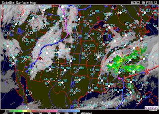
This map shows the low (also located towards the base of Minnesota, corresponding with the jetstream map) And you can see that it has continued to move towards the northeast throughout the day. You can see there is 100% cloud cover in the midwest, and areas associated with the winds that are supplying the low coming up from mexico, and the winds associated with the Low throughout the middle United States.


In this water vapor map you can see that where we have 100% cloud cover, we also have water vapor. The water vapor patterns, wind patterns, and cloud patterns, are all related to the Low pressure system. I have drawn the wind direction and the Low pressure system on the two maps below to show the relationship.


The winds have started to shift and are coming a little more from the east than the south east than they were earlier today. This makes me think that the Low pressure system will hit us more directly than we though earlier because it doesnt have such direct southeast winds pushing it north of us. 

After looking at the weather forecast, I noticed that they are predicting us to receive 4 inches of snow, rather than the 2 inches of snow that was predicted earlier. If the winds continue to shift throughout the night I believe that we will get even more snow. Although I do not know how to predict if the winds will shift, I do notice that as the Low pressure system nears us, the winds have begun to feed into its counter clockwise direction. This makes me wonder if the winds will continue to shift in a counter clockwise motion (until they end up coming from the north) as the storm nears. 

One thing that I have found interesting throughout this, is that the two stability charts shown above show a highly stable atmosphere. This leads me to believe that the snow storm wont be bad, because stability charts related to severe storms will not look like this.

Here are two pictures I took tonight of the snow!


Weathering the snow & rain in the design lab Haas!
(& showing friends how to look at weather maps and understand what's going on!)


Monday, February 27

Weather blog #11

"Tracking the Snow Storm"

MONDAY
Early Afternoon


over the course of the next three days I'm going to work to view maps multiple times per day to see how the weather progresses as the snowstorm comes through. Rumor has it that we are supposed to be receiving what could possibly be the worst snowstorm February has ever seen.

As of this morning, there was 100% cloud cover-alto stratus clouds, and a brisk temperature.
By 11am the clouds had started to break up-it appears to be alto cumulus clouds but I would have consult my book to be sure. Because they are starting to clear this leads me to believe that barometric pressure has been rising because that leads to clearing conditions. I went and looked at the daily history on the UWEC website and found that I was correct:


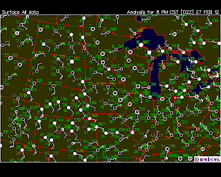
Here are some current surface maps:


We have winds of about 10-15mph coming from the west. They are carrying winds from the Continental polar air mass which is why the temperatures have cooled down. Also, the cold front that was located to the west of us yesterday has passed through and is moving towards the east. There is a stable front over the rockys-which I will watch for change over the next 24 hours because movement from the high pressure system over the mountains is what is supposed to be responsible for the predicted snow storm.

The relative humidity right now is 59%-Because I know there is a snow storm on its way, I know that the relative humidity will have to increase because there will be more moisture in the air. I will check this later today and tomorrow to see if I am correct.

ALSO
Yesterday I was correct! I said that we had a chance of precipitation later-I was clued in by the falling barometric pressure-and indeed we got snow last night!

LATE MONDAY
The clouds continued to clear as the day went on-0% cloud cover by 5pm. The relative humidity is still 59% but I still expect this to increase because we are predicted to have freezing rain and up to 3 inches of snow tomorrow.

Here are some maps from late Monday night:


You can see that the Barometric pressure is starting to level off-I will relate this to the idea that rising barometric pressure means clearing and falling barometric pressure means it will get cloudy/worse weather conditions/precipitation.

You can see that the clouds have continued to move eastwards towards us. The low pressure system is still stable and located above the Rocky Mountains. Although I'm not good at this yet, I will take a stab at it and say that because of the stable front above the low pressure system, I think that the direction of the storm will not go above us, but rather pass right over us or below us. We are recieving winds from the south west which will continue to bring the low pressure system (and therefore the winter storm) in our direction.

Sunday, February 26

Weather Blog #10

SUNDAY
The temperature is 39 degrees but it feels like 33. We have 100% cloud cover-alto cumulous duplicatus clouds. In Field Guide to Weather it says that this type of cloud is usually related to more important weather changes and conditions. Also, they are largely composed of water droplets and are form where there is a lot of moisture. These clouds are responsible for transporting moisture over long distances. The winds are circling around a low pressure system and we are getting winds from the south. Winds are about 20mph.


The barometric pressure is falling which means that we will not have clearing conditions. Since when it rises it means that rain/clouds etc. will clear, I would predict that since it is falling today that we have a chance of precipitation later today.


THURSDAY

Last night the pressure systems switched and instead of the country being under multiple low pressure systems, it is now under multpile high pressure systems.  We have 0% cloud cover and little to no wind. There is a a storm on ht eeast coast that looks like it will progressively move towards the atlantic as the fronts to the west of it continue to move across the country.


WEDNESDAY
On Wednesday we had no winds and clear skies. When you look at the map of surface conditions you can see that the blue lines are located very far apart, which further shows that we don’t have wind.  Surrounding areas have winds coming from the south west, and there is a cold front to the west of us.


As the day progressed, the south west winds blew the cold front across the country and shifted the winds so that they are now coming from the north west. We ended the night with 100% cloud cover.


TUESDAY
Today we got snow. There is a low-pressure front & winds from the south. Because of the way the winds were rotating, the center of the low was above us, which is why we had snow. If the center of the low had been below us we would have had winds from the north and we would not have gotten snow.

-we discussed this concept in class; however I don’t quite understand why we get snow when the wind is coming from the south, but we wouldn’t get it if the winds had been from the north-I feel like it should be the other way.

We have a cold front moving in from the west and once it passes we’ll get winds from the northwest. We will see clearing conditions once the wind switches because it will blow the clouds through.
-You can see this on barometric history charts because if it is rising we will have clearing conditions.


Monday, February 20

WEATHER BLOG #9

"Getting to the bottom of what causes it to snow"


MONDAY-EARLY
Today the morning began with 100% cloud cover. They were the kind of clouds that don't look like its completely covering the sky because they aren't dark and thick and the sun is shining through, but you know they are because there is no stopping point. As the day went on the temperature got warm-i'm guessing it was in the upper thirties, there was no wind (although surrounding areas had winds from the south east), and the skies completely cleared. There is a stationary front located directly above us, and a cold front to the west. We are also located to the right of some ridges surrounding a low pressure system.


MONDAY-LATE
As the day progressed we developed winds from the southeast that were about 15-20mph. It feels very warm-I didn't need mittens walking outside even at 11pm! This is because the winds are coming from the Maritime Tropical (Atlantic) air mass. Also, as evening fell we developed cloudy skies and precipitation. My question, is why was there precipitation? I have a map from this morning when there was sun no precipitation, and a map from this evening after the snow began to fall, and I cannot figure out what causes this to happen.


MY HYPOTHESIS
I think that the reason we have precipitation has to do with the high pressure system that was located on the east coast earlier this afternoon. Because air rushes from high to low pressure, and we were located in a low pressure system, it blew the weather our way-which is also why we were receiving winds from the southeast!

PREDICTION
Because the air will continue to go from the high pressure system out east towards the low pressure system where we are i predict that our weather will stay similar for a while.
-->this will cause us to have snowfall for a while and also have warm winds coming from the Maritime Tropical (Atlantic) air mass.

Also, there is a stable front located above us and I wonder if that will have anything to do with how fast the storm will leave our area? Since it is blowing from south east towards the northwest I think that once it hits the stable front it will slow down (and possibly stop) making it so that we continue to receive precipitation until the clouds are no longer saturated.

Below is a map of what the surface weather is supposed to look like in 12 hours. This shows that we will still be getting winds from the south east, and we will continue to have cloud cover and precipitation-it will possibly begin clearing in mid afternoon because the clouds will be starting to move past us.


SUNDAY
We are located in a low pressure cell, we have 100% cloud cover of altostratus clouds. The temperature is 39 degrees but it feels like 33. There is winds coming from the south/southeast at about 20 mph-you can see on the map that the rotation of the winds directly corresponds with the low pressure system that is over us.


THURSDAY
Unfortunately I spent most of the day inside on Thursday-so I didn't get a chance to be outside in the beautiful weather we had! We had little winds, no clouds, and it was very warm! Unfortunately for the east coast, they did not have weather as nice as us! This map shows that they are getting hit by a storm coming from the Atlantic. They had 100% cloud cover and winds at about 10mph. 


Thursday, February 16

WEATHER BLOG #8

Although I have been having trouble posting every day (as I am in dance, lacrosse, NOTA, have 3 jobs and 15 credits) I have been saving weather maps each day and trying to write down a few quick notes while I'm on my way from activity to activity so that when I have time to write in my blog I will have the information I need!

WEDNESDAY
-to be inserted later this afternoon-

THURSDAY
9:15AM


Today it is beginning to warm back up again. it is a high of 37 degrees. We have winds coming from the west at about 10mph.


We also have 100% cloud cover. The couds look like they are Altostratus. According to Field Guide to Weather these clouds mean that there is moisture and temperatures that range from slightly colder than to slightly warmer than freezing. In order for these clouds to occur there has to be a continuous wind pattern because it has to go through gradual lifting until saturation occurs. This makes sense because we have had winds coming from the west/northwest almost every day for the last week.

Although these clouds are formed because of moisture being in the sky, it doesn't necessarily mean precipitation. The book says that if they are increasing over time that there may be precipitation coming, but if they are remaining the same, than they probably wont do anything.

My personal goal today is to watch the clouds to see if they change-and whether or not that results in precipitation.

Reading this helps me understand why last Saturday why the on again off again precipitation we had was occurring. I noticed that there would be cloud cover, then it would go away. Then more would roll in, then they would go away. My prediction is that it was caused by these types of clouds and since they were changing and increasing as the day went on, they were bringing precipitation with them.

OBSERVATIONS FROM LAST POST
-I was interested to see that we got precipitation on monday, because the water vapor charts showed no evaporation in our area. In other areas of the country where it was snowing/raining they all had visible water vapor above them on the map. I was wondering that afternoon why it was snowing here? Now after reading about clouds today, I wonder if it had something to do with that-possibly the place where our winds were coming from had evaporation that blew down to us-therefore precipitating on us.

Monday, February 13

WEATHER BLOG #7

TODAYS WEATHER
100% cloud cover-altostratus clouds.
We are still in ridges that are going deep through the country-they are carrying winds coming from the south/south east which is why the temperature (20 degrees at 8:30am) feels warmer than it has the past few days (it was in the teens) when we were getting winds from the north west.


In the middle US they are getting some rain/ice/snow and light flurries. This makes sense because yesterday on the water vapor map it showed a lot of water vapor in that area-the clouds must have become saturated and now they are receiving precipitation.


Saturday, February 11

WEATHER BLOG #7


FRIDAY
Yesterday I really wanted to study the maps of the weather; unfortunately, I was at work from 8-7 and didn’t have Internet access to get any maps. The weather was really interesting and I would like to try and get access to some maps from yesterday to see why the weather was the way it was. The morning was cloudy and cold, and then the clouds started to clear-I noticed that it looked like a combination of stratus clouds and cumulus clouds. Around noon the sun started to peak out and by the time the sun went down we had almost 100% clear skies. The thing that I don’t understand, and would like to know what type of conditions causes this, is that we had precipitation multiple times throughout the day. The temperature was really cold, which leads me to believe we had northwest winds, which would carry down air from the continental polar air mass.

SATURDAY
Today it looks like it is nice and warm because it is sunny and we have only about a 20% cloud cover of really light STRATUS??? Clouds. However, it is very chilly with winds coming from the northwest at about 20 mph.


This map shows that we have clear skies and winds coming from the northwest. It also shows that Eau Claire is located in some ridges that have formed-the perfect way for winds coming from the continental polar air mass to travel in. There are no clouds to the northwest direction of Eau Claire, which leads me to believe that the sky will stay relatively clear all day. This means that the temperature tonight  and tomorrow morning will be very cold because the clouds wont be in the sky to keep any warm air in.

ELSEWHERE IN THE COUNTRY
There is a stable front and a low-pressure system located over the rocky mountains-this is most likely because of an effect that the Rocky Mountains is having on the way the weather can travel.

OBSERVATION
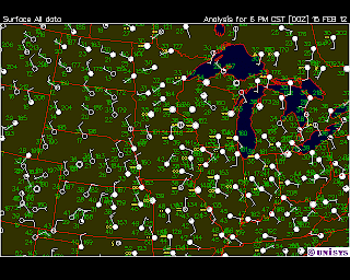
Since I am still new to weather and don’t know much about predicting it yet, I wanted to pull a surface map from last week to compare what it looks like when the weather is warm, compared to what a map of today looks like when the temperature is very cold. I noticed that when it was warm we did not have these deep ridges cutting through the center of the country from the continental polar air mass area down to Texas. This leads me to believe that it is these ridges, which will allow the cold air to easily be transported down through Canada and the United States.  Assuming I am correct, this observation will allow me to look at 24-hour surface maps and be able to predict whether it will be warm or cold.

WARM WEATHER SURFACE MAP


COLD WEATHER SURFACE MAP

Thursday, February 9

WEATHER BLOG #6

TUESDAY FEBRUARY 7
Today I did my weather briefing. The day started off with 100% cloud cover. the winds were coming from the northeast and were expected to shift towards the north throughout the day. There was a high pressure system coming down from the continental polar air mass. The clouds were expected to clear throughout the day as the high pressure system moved through and indeed, they did-there were clear skies by mid afternoon.


WEDNESDAY FEBRUARY 8
The temperature began dropping. There is a cold front moving through, as well as the jet stream dipping a bit lower in the country which is causing the temperature to cool off. There was a slight wind, and about 85% cloud cover in the morning, but as the day went on it warmed up and some of the clouds cleared. The temperature dropped probably into the low teens at night-it was really chilly.

THURSDAY FEBRUARY 9
Today there are mild winds coming from the south east. you can see this on the map below in the little white circles with the line sticking off it towards the south east (I do not remember what they are called). because of that, the temperature will be a little warmer than if we were getting winds from the north; however, it is still cold because there is a cold front moving towards us via continental polar air mass.

Monday, February 6

Weather Blog #5

This weekend the weather finally changed! we had about a 10% cloud cover on saturday and temperatures must have gotten up into the 40s. There was little to no wind and it was really nice out! On Sunday the morning started out the same, but mid-afternoon the weather changed and we ended up with an 80% cloud cover and a slight wind. The temperature still stayed mild-probably in the upper 30s.

Today the morning began (around 9am) with about a 75% cloud cover, a slight wind, and temperature in the mid 30s. By 11:30 the clouds were clearing and the temperature began rising-I would guess it's in the low 40s right now. Currently there is 0% cloud cover and I expect that the weather will continue to be warm throughout the rest of the day. I think that there is a high humidity/dew point due to the amount of evaporation that is occurring because of the warm temperatures that are melting the snow.

Friday, February 3

Weather Blog #4

The weather is the same as it has been for the past two days. There is 100% cloud cover, little or no wind, and the temperature is probably around 34 degrees. I do not know what else to say because in the last three days I have said just about everything that I currently know about this type of weather. I would predict it to change soon since it's been the same for so long; however, I do not know what types of factors will cause it to shift.

Thursday, February 2

Weather Blog #3

Today there was 100% cloud cover again. The temperature is even warmer than yesterday-probably in the high 30s. there is almost no wind. Because of this, I believe that there is some sort of system sitting directly above us that is not moving-which is why there has been 100% cloud cover for two straight days. Because of the low wind, I think that a barrometric pressure map would show lines that are relatively far apart-meaning that the wind is not rushing from high pressure to low pressure in order to even itself out.

Wednesday, February 1

Weather Blog #2

Although I am posting late, I did my weather observation at 8:50am this morning on my walk to class. This morning we had 100% cloud cover. Because of this, I could not tell weather they were stratus or cumulous clouds. There is a slight wind and the temperature feels around 30 degrees. There is a lot of moisture in the air-probably due to the warm temperatures that have caused the snow to melt. Because of this moisture I and the cloud cover, I would predict that it will rain or drizzle at some point this afternoon. I also expect that the temperature will not drop below 23 degrees until late this evening.

I believe I was wrong, I do not think that it rained at all today. However, I was correct on the fact that it stayed a very mild temperature throughout the day.