Saturday, April 28

Changing Wind Directions

This week has been a great week to see how the cloud patterns can show what the weather will be like the following day. Earlier this week, on tuesday afternoon, I noticed the clouds starting to break apart and look patterned-which is a sign of changing wind direction. Since it was really nice on tuesday and I knew from the weather briefing earlier that day that we were on the south side of a low pressure system, I was able to predict that the system was now moving over us and we would be experiencing cooler temperatures on wednesday-I was correct! I was even correct in predicting that we would have precipitation as it moved through. I was in the Haas design lab until 5:30am, and when I left I noticed that it had recently rained, so sometime during the night as the low pressure system and warm front were moving over us, it rained.

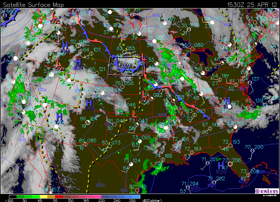
Here is a surface map of wednesday, to show that we were on the backside of the low pressure system. It makes sense that it was slightly to the west of us because temperatures didn't drastically drop as they would have if we had been more directly behind the cold front.


It happened again yesterday! I noticed the same type of clouds and predicted that today would be cool-low and behold I awoke to a sky blanketed in stratus clouds and temperatures that made it chilly even in a sweatshirt and pants! I really like that I have been able to pick up on these patterns because this will be extremely useful to know what type of weather to expect in days to come incase I am planning on being outside!

It's funny because on both of these occasions I was with friends, and shared this information with them. They brushed it off like I didn't know what I was talking about, and then the next day, when my predictions had been correct, they were impressed that I was right and wished they knew these types of things too :)

I fell like when we originally learned about these types of clouds, it was supposed to signal changing winds in a good way, that the next day would be nicer. But I have come to notice that it depends on what type of pressure system is near you and also what the weather previously was. If its really nice out, and the winds start changing, chances are its going to become cooler. If its already pretty crappy out and the winds start changing, the new wind direction will push out the crappy weather and it will get nicer!

Here is a surface map of today:


Wednesday, April 25

Today is supposed to get up to 50 degrees, which is nice, but not as nice as yesterday! I woke up and it looks like we have some stratus clouds blanketing the sky. we have winds coming from the east/southeast at about 10 mph. Because of this I expect that at some point today it will rain. After looking at barometric trends I noticed that the pressure has been pretty inconsistant, but is currently falling. I think that if this stays consistant that one of the times it starts falling we will see a little bit of precipitation.

The surface map shows that there a low pressure system just to our west that has two stationary fronts extending from it. Because of this I will expect this weather to hold consistant today until these stationary front develop. After this begins to move I predict that we will have precipitation while it passes and then our temperatures will drop because the cold front trailing the low pressure system will allow the arctic winds to hit us.

On the surface map you can also see that the isobars from the south are extending further north above the warm front extending from our low pressure system. This is because the moisture associated with a  system like this comes from the south and often will cause thunderstorms and rain just north of the warm front. This explains why our relative humidity is 80% today, as our air is thick with moisture from the Maritime Tropical air mass!

Also, I was curious to see how our atmospheric stability was incase we might be in for a thunderstorm today! But as it turns out, our atmosphere is stable and we will probably just receive precipitation.


Monday, April 23

I spent the weekend in Minneapolis touring design studios and having one-on-one interviews with professional designers. although I didn't have internet while we were there that doesn't mean I wasn't paying attention to the weather! Saturday there were some crazy looking cumulus congestus clouds and sure enough, it began raining that afternoon and didn't stop until very late saturday night. Yesterday on my drive home from Minneapolis I noticed there was a mackerel sky which means that the winds are changing- today the weather should be nice!

I woke up to sun shining through my window and very little cloud cover. Temperatures are supposed to get up to 60 degrees today! we have winds coming from the North. The rest of the day should be nice and I predict that tomorrow will be nice weather too.


Tuesday, April 17

Storms!

It has been a crazy weekend for weather in the midwest! Towards the end of last week the temperatures were down in the 40s, then it jumped yesterday to the 60-70 range, and it was back down to 35 degrees and snowing this morning!! Because of all of these cold and warm fronts moving through, the air has been mixing a lot causing conditions to be unstable. Yesterday we spent most of the day under a tornado watch-this is because since the cold air was coming in it was displacing the warm air which was causing it to mix and form a mid latitude cyclone-which can result in a tornado. Luckily, we didn't have any tornadoes-but we did experience off and on rain and some ferocious looking Cumulus clouds!

Today the day began cloudy and it was lightly snowing! We had winds coming from the northwest at about 10-15mph and the atmosphere was conditionally unstable. By looking at the sky I would have predicted it to rain through out the day, but after looking at a map you can see that since the cold front has passed it is not likely to precipitate because we are on the backside of the storm.


MONDAY MORNING STABILITY

MONDAY EVENING


TUESDAY MORNING
The conditions right now are stable, no clouds, no wind, moderate temperature. It appears as though it will stay this way throughout the day as there is a stable front that has formed to our west-just to the northeast of the Rocky Mountains.


Thursday, April 12

Tornadoes

Today there is the possibility for developing tornadoes in the middle United States. This is because the high pressure system located in the midwest is causing dry winds to shoot towards states such as Kansas, and Nebraska. These dry winds combined with the moist air coming up from the continental tropical air mass and the jet stream from the west will cause a lot of mixing of air which will provide the perfect opportunity for tornadoes to form.

In the midwest we have no wind, no clouds. However, I expect that throughout the day we can expect to see more cloud coverage moving in from the west because since the High pressure system is tour our south east, we will be getting winds from the west-which you can see on the map below has clouds and some rain showers. Another reason I am led to believe that it will rain later is because the barometric pressure is dropping, which means we can expect precipitation.


Monday, April 9

Brrr!

This morning we had cumulus humulus clouds to our north, and clear skies to our south. Although it looked like it was warm, the winds make it very cold! When I walked outside and felt them, it was obvious to me that the winds were coming from the north/northwest. I was correct! Another thing contributing to our cold winds today is the fact that we are currently in a trough. You can see in the map below that the jet stream is dipping down across the middle united states allowing the cold arctic winds to have a nice path straight to us. There is a stable front located on the west edge of this trough, which leads me to believe that it will be a while before these cold winds pass through.


Thursday, April 5

Weather Blog #17

The weather this week has been really interesting to follow! This spring weather changes much more than the weather we had during the winter months. There have been a lot of changes in wind patterns in the last week because of all the low pressure systems passing under us. 

Here are some maps from monday afternoon. You can see there is a low pressure system to our south west causing us to have winds from the southeast. Whenever there are winds coming from this direction you can be prepared for precipitation. In the morning we had stratus clouds and as the day went on they became alto stratus clouds-this made me wonder if we would possibly be seeing precipitation later because this is part of the warm-front sequence.


sure enough, Monday night we had a crazy thunderstorm! Here are the maps from around midnight-right before the storm hit! You can see the barometer decreasing which means that precipitation is coming, we are also continuing to get winds from the southeast. It's interesting because the storm we had sounded pretty intense, but these maps and charts don't show anything that looks much different from those I have from earlier in the day. How can weathermen predict how severe a storm is going to be?