"Tracking the Snow Storm"
MONDAY
Early Afternoon
over the course of the next three days I'm going to work to view maps multiple times per day to see how the weather progresses as the snowstorm comes through. Rumor has it that we are supposed to be receiving what could possibly be the worst snowstorm February has ever seen.
As of this morning, there was 100% cloud cover-alto stratus clouds, and a brisk temperature.
By 11am the clouds had started to break up-it appears to be alto cumulus clouds but I would have consult my book to be sure. Because they are starting to clear this leads me to believe that barometric pressure has been rising because that leads to clearing conditions. I went and looked at the daily history on the UWEC website and found that I was correct:
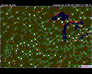
Here are some current surface maps:
We have winds of about 10-15mph coming from the west. They are carrying winds from the Continental polar air mass which is why the temperatures have cooled down. Also, the cold front that was located to the west of us yesterday has passed through and is moving towards the east. There is a stable front over the rockys-which I will watch for change over the next 24 hours because movement from the high pressure system over the mountains is what is supposed to be responsible for the predicted snow storm.
The relative humidity right now is 59%-Because I know there is a snow storm on its way, I know that the relative humidity will have to increase because there will be more moisture in the air. I will check this later today and tomorrow to see if I am correct.
ALSO
Yesterday I was correct! I said that we had a chance of precipitation later-I was clued in by the falling barometric pressure-and indeed we got snow last night!
LATE MONDAY
The clouds continued to clear as the day went on-0% cloud cover by 5pm. The relative humidity is still 59% but I still expect this to increase because we are predicted to have freezing rain and up to 3 inches of snow tomorrow.
Here are some maps from late Monday night:
You can see that the Barometric pressure is starting to level off-I will relate this to the idea that rising barometric pressure means clearing and falling barometric pressure means it will get cloudy/worse weather conditions/precipitation.
You can see that the clouds have continued to move eastwards towards us. The low pressure system is still stable and located above the Rocky Mountains. Although I'm not good at this yet, I will take a stab at it and say that because of the stable front above the low pressure system, I think that the direction of the storm will not go above us, but rather pass right over us or below us. We are recieving winds from the south west which will continue to bring the low pressure system (and therefore the winter storm) in our direction.


No comments:
Post a Comment