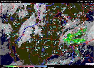
MONDAY-EARLY
Today the morning began with 100% cloud cover. They were the kind of clouds that don't look like its completely covering the sky because they aren't dark and thick and the sun is shining through, but you know they are because there is no stopping point. As the day went on the temperature got warm-i'm guessing it was in the upper thirties, there was no wind (although surrounding areas had winds from the south east), and the skies completely cleared. There is a stationary front located directly above us, and a cold front to the west. We are also located to the right of some ridges surrounding a low pressure system.
MONDAY-LATE
As the day progressed we developed winds from the southeast that were about 15-20mph. It feels very warm-I didn't need mittens walking outside even at 11pm! This is because the winds are coming from the Maritime Tropical (Atlantic) air mass. Also, as evening fell we developed cloudy skies and precipitation. My question, is why was there precipitation? I have a map from this morning when there was sun no precipitation, and a map from this evening after the snow began to fall, and I cannot figure out what causes this to happen.
MY HYPOTHESIS
I think that the reason we have precipitation has to do with the high pressure system that was located on the east coast earlier this afternoon. Because air rushes from high to low pressure, and we were located in a low pressure system, it blew the weather our way-which is also why we were receiving winds from the southeast!
PREDICTION
Because the air will continue to go from the high pressure system out east towards the low pressure system where we are i predict that our weather will stay similar for a while.
-->this will cause us to have snowfall for a while and also have warm winds coming from the Maritime Tropical (Atlantic) air mass.
Also, there is a stable front located above us and I wonder if that will have anything to do with how fast the storm will leave our area? Since it is blowing from south east towards the northwest I think that once it hits the stable front it will slow down (and possibly stop) making it so that we continue to receive precipitation until the clouds are no longer saturated.
Below is a map of what the surface weather is supposed to look like in 12 hours. This shows that we will still be getting winds from the south east, and we will continue to have cloud cover and precipitation-it will possibly begin clearing in mid afternoon because the clouds will be starting to move past us.
SUNDAY
We are located in a low pressure cell, we have 100% cloud cover of altostratus clouds. The temperature is 39 degrees but it feels like 33. There is winds coming from the south/southeast at about 20 mph-you can see on the map that the rotation of the winds directly corresponds with the low pressure system that is over us.
THURSDAY
Unfortunately I spent most of the day inside on Thursday-so I didn't get a chance to be outside in the beautiful weather we had! We had little winds, no clouds, and it was very warm! Unfortunately for the east coast, they did not have weather as nice as us! This map shows that they are getting hit by a storm coming from the Atlantic. They had 100% cloud cover and winds at about 10mph.


No comments:
Post a Comment